Overview
The 378-acre Zoar State Forest is located in King William County, near Aylett. The forest is split into two separate noncontiguous units separated by 1,900 feet along Route 600. The northern unit (“Upper Zoar”) has a thin strip of upland land that gives way to a steeply-sloped hillside falling into the floodplain of the Mattaponi River. This is the site of a nature trail and canoe launch and is mainly managed as a natural area for recreation and wildlife. The southern unit (“Lower Zoar”) comprises more than 80% of the property. It is characterized by good site and timber quality on the upland soils, thanks to a long history of forest management activities by the Stoddard family. It has gentle terrain, good access, and a varied flora resource, exhibiting the potential for excellent pine and hardwood growth. The forest provides an excellent venue for producing high-value pine and hardwood timber, providing opportunities in education and recreation, and a variety of wildlife habitats.
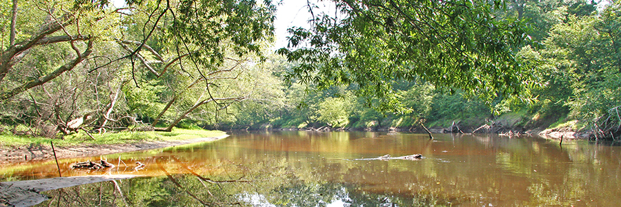
Water resources include a 4-acre pond, 2,000 feet of waterfront on Herring Creek, and 6,600 feet of waterfront on the Mattaponi River.
The property includes a 1901 home that houses the DOF office. The house and outbuildings are on the National Register of Historic Places.
At a Glance
Access Status: Open to the Public
Hours: Open daily from dawn until dusk
Physical Address:
Latitude/Longitude:
37° 47’ 43”, -77° 6’ 51”
Office: 4445 Upshaw Road, Aylett, VA 23009
Parking/Access: Access from Upshaw Road or River Road. Small parking area at 4445 Upshaw Road (DOF Office) and 1.75 miles west of Aylett on Route 600, River Road.
Restroom Facilities: None
Visitors are asked to adopt a “leave-no-trace” ethic when visiting the forest, as there are no restrooms or trash cans on the forest itself.
Other Facilities: None


Local legend has it that the Village of Aylett, being a vibrant crossroads and destination of colonial travelers, was rife with sin and crime. The property was called Zoar by its early owners in reference to the biblical city of Zoar, which was spared the brimstone and fire that destroyed Sodom and Gomorrah, and provided a refuge for Lot and his daughters.
The property includes a one-and-one-half story Queen Anne style single family dwelling, built in 1901, to replace an earlier farmhouse that burned down, and a number of outbuildings near the central dwelling exist that served the 19th century farmstead. Located 218 feet to the north of the present dwelling is the stately Pollard Family Cemetery, enclosed within a significant brick wall with a handsome wrought iron gate. Within the walls are a number of graves dating from 1789 to 1883.
Historical Landmarks
In 2005, the house and surroundings were listed in the Virginia Landmarks Register by the Virginia Department of Historic Resources. It was subsequently voted onto the National Registry of Historic Places in 2007. The registry recognizes the historic value of a property and encourages present and future owners to continue to exercise good stewardship, while imposing few, if any, restrictions on the use, management, or alteration of the facilities.
A few management highlights at Zoar include an exceptional 90-acre pine stand that has been thinned twice and has excellent potential for understory burning. It has an accessible hardwood stand that has potential for improvement, and various ages of longleaf pine plantings that serve to demonstrate forest management alternatives.
At a Glance
Visitors are asked to adopt a “leave-no-trace” ethic when visiting the forest, as there are no restrooms or trash cans on the forest itself.
ATV/ORV use, camping, and swimming are prohibited on all State Forests.
A State Forest Use Permit* is required for individuals aged 16 and older to hunt, fish, trap, horseback ride, or mountain bike on state forest lands. The permit can be purchased online or where hunting licenses are sold.
Trails and Roads
- 1.5 miles of forest trails (no vehicles)
- 0.2 mile of forest roads (vehicles allowed)
- 0.6 miles of gated forest roads (no vehicles)
Hiking
Hiking is permitted on all forest roads and the nature trail (Upper Zoar, on River Road).
Mountain Biking *
Mountain is permitted on all forest roads and the nature trail (Upper Zoar, on River Road).
Horseback Riding *
None
Fishing and Boating
Only non-motorized boats are allowed on state forest waterways.
Fishing is permitted in the Mattaponi River in accordance with state fishing regulations. Both a State Forest Use Permit and Virginia fishing license are required.
A canoe/kayak launch is located off River Road on Herring Creek, giving access to the Mattaponi River.
Hunting and Trapping
None
Other Recreational Opportunities
Other passive recreational opportunities, such as wildlife watching and nature photography, are available.
- Self-learning opportunities are available.
- Self-guided educational opportunities – interpretive signs.
The property is available to students, researchers, and the general public for nature study and other self-directed learning.
State Forest Main Office
Located at Cumberland State Forest
751 Oak Hill Road, Cumberland, VA 23040-2511
E-mail | (804) 492-4121
Local Contact
Dennis Gaston, Forest Manager
11301 Pocahontas Trail, Providence Forge, VA 23140
E-mail | (804) 966-2209
| Image | Title | ID | Description | Content Type | View | hf:tax:document-category | hf:tax:Media |
|---|---|---|---|---|---|---|---|
 | Zoar State Forest – General Map | General map of Zoar State Forest. To ensure your safety and enjoyment, please read Before You Visit when planning your trip to a state forest. Download or print this state forest map – many state forests are remote with limited cell phone service. These maps will work with Avenza Maps™, a mobile map app that allows you to track your movements offline on your iOS and Android device without the need for cell service or internet connection. A free version of this app can be downloaded to your device through your app store. | Map | View | state-forests | map |