
Overview
Browne State Forest is a 128-acre property in Essex County, consisting of mostly loblolly pine forest, with some wetlands along Dragon Run Swamp. The forest is maintained for demonstration of scientific forest management, applied forest research, development of diverse wildlife habitat, watershed protection, biological diversity, and passive outdoor recreation.
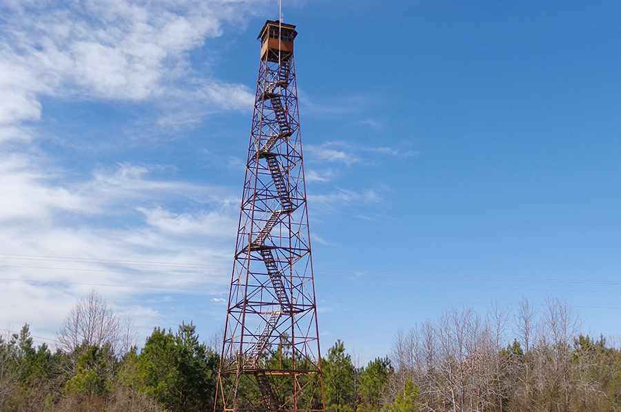
Along Route 604 on the forest is a fire tower, moved there from King George County in the early 1960s. The Middle Peninsula Chesapeake Bay Public Access Authority owns land adjacent to the State Forest, crossing the Dragon Run into King and Queen County with a boardwalk and system of trails.
At a Glance
Access Status: Open to the Public
Hours: Open daily from dawn until dusk
Physical Address:
Latitude/Longitude:
37° 47’ 25.4”, -76° 46’ 49.7”
Parking/Access: Access from Rt. 604, Byrd’s Bridge Road, in Essex County
Parking area for only one vehicle is located near the gate; do not block the gate
Restroom Facilities: None
Visitors are asked to adopt a “leave-no-trace” ethic when visiting the forest, as there are no restrooms or trash cans on the forest itself.
Other Facilities: None
Seasonal Closures: None
DOF recommends that all forest visitors wear blaze orange or pink during hunting seasons.

Forest History
Browne State Forest was established in 2005. The property edges the Dragon Run Swamp that defines the border between Essex and King and Queen counties. Widely considered Virginia’s most pristine blackwater stream, Dragon Run (labeled as Dragon Swamp on most topographic maps) meanders for nearly 40 miles through remote portions of four eastern Virginia counties.
The earliest deed reference to this property (in the courthouse records) dates back to October 13, 1892, when Andrew C. Browne transferred the property to James R. Browne of Baltimore, Maryland. How long the property was in the Browne family before that is unknown, but a gravesite adjacent to the state forest property, on the Public Access Authority land, has Andrew C. Browne’s name on the central monument. That same monument also notes other names including, “Father, John C. Browne, Born in Scotland.”
The property was still owned by members of the Browne family when, in 1956, it was sold at a court-ordered public auction. Chesapeake Corporation acquired the property and called it the Brown Tract #1811 (Brown, without the “e”). Reference is made in all earlier deeds to an ice pond in the northwest corner of the property along the Dragon Run, but evidence of that on the ground has been obliterated by time.
In 2002, the Middle Peninsula Chesapeake Bay Public Access Authority came into being, with the purpose of improving public access to the state waters of Virginia. Shortly after its creation, the Public Access Authority acquired a 261-acre tract from John Hancock Life Insurance Company, using a grant from the Virginia Coastal Resource Management Program. As a condition of that grant, the Public Access Authority was required to transfer roughly half of the acreage to the Virginia Department of Forestry, paving the way for establishment of Browne State Forest.
Forest Management
Management on this forest focuses on demonstration of scientific forest management, applied forest research, development of diverse wildlife habitat, watershed protection, passive recreational opportunities, and eventual development of diverse timber stands that support biological diversity. Just two years before the acquisition, John Hancock Insurance Company had harvested the majority of commercial timber on the property and reforested it with loblolly pine. Currently, 94% of the total land area is forested with loblolly pine plantations, typical of eastern Virginia land with a history of forest industry ownership.
The Dragon Run Watershed is an important ecological community, described by the Smithsonian Institute as the “second most ecologically important watershed in the Chesapeake Bay.” Michael Lipford, director of The Nature Conservancy, said, “The Dragon Run watershed is one of the few watersheds in eastern Virginia that remains primarily undeveloped, rural forest land.”
The Public Access Authority’s portion of the land is adjacent to the state forest and spills over the Dragon Run into King and Queen County. That property has a system of trails, water access and a hunter registration process. The state forest land complements this recreational development by providing contiguous undeveloped acreage.
Recreational Opportunities
Recreational uses of the Browne State Forest include hiking, wildlife watching, hunting, and trapping.
Visitors are asked to adopt a “leave-no-trace” ethic when visiting the forest, as there are no restrooms or trash cans on the forest itself.
ATV/ORV use, camping, and swimming are prohibited on all State Forests.
A State Forest Use Permit* is required for individuals aged 16 and older to hunt, fish, trap, horseback ride, or mountain bike on state forest lands. The permit can be purchased online or where hunting licenses are sold.
Trails and Roads
- 1/2 mile of gated forest roads (no vehicles)
- No driving past forest gates.
Hiking
Hiking is permitted on forest roads.
Mountain Biking
None
Horseback Riding
None
Fishing and Boating
None
Hunting and Trapping
Hunting and trapping are permitted with a valid State Forest Use Permit and valid hunting license in accordance with state regulations and Essex County firearms regulations.
Note that some regulations may be different than on private land, so check Virginia Department of Wildlife Resources Hunting Regulations for specific state forest details.
Other Recreational Opportunities
Other passive recreational opportunities, such as wildlife watching and nature photography, are available.
Educational Opportunities
Self-learning opportunities are available.
Contact Us
For more information or questions, e-mail us or use our contact form.
State Forest Main Office
Located at Cumberland State Forest
751 Oak Hill Road, Cumberland, VA 23040-2511
E-mail | (804) 492-4121
Local Contact
Dennis Gaston, Forest Manager
11301 Pocahontas Trail, Providence Forge, VA 23140
E-mail | (804) 966-2209
Maps and Additional Resources
| Image | Title | ID | Description | Date | Content Type | View | hf:tax:document-category | hf:tax:Media |
|---|---|---|---|---|---|---|---|---|
| Browne State Forest Hunting Season Brief | Information sheet summarizes hunting seasons, dates, and times for Browne State Forest. | 08/19/2025 | Document | View | state-forests | document | ||
 | Browne State Forest – General Map | General map of Browne State Forest. To ensure your safety and enjoyment, please read Before You Visit when planning your trip to a state forest. Download or print this state forest map – many state forests are remote with limited cell phone service. These maps will work with Avenza Maps™, a mobile map app that allows you to track your movements offline on your iOS and Android device without the need for cell service or internet connection. A free version of this app can be downloaded to your device through your app store. | 08/14/2023 | Map | View | state-forests | map | |
 | Browne State Forest – Hunting Map | Hunting map of Browne State Forest. To ensure your safety and enjoyment, please read Before You Visit when planning your trip to a state forest. Download or print this state forest map – many state forests are remote with limited cell phone service. These maps will work with Avenza Maps™, a mobile map app that allows you to track your movements offline on your iOS and Android device without the need for cell service or internet connection. A free version of this app can be downloaded to your device through your app store. | 08/14/2023 | Map | View | state-forests | map |