The Virginia Department of Forestry (DOF) manages 26 state forests totaling 75,732.4 acres. The state forests of Virginia are self-supporting and receive no taxpayer funds for operation. Operating funds are generated from the sale of forest products, the purchase of state forest use permits, and Virginia’s income tax check off system.
The formation of the state forest system created a way for the Commonwealth to manage working forestland for a steady supply of timber. In addition, the state forests ensure operation and maintenance of this natural resource, help maintain a stable local economy, provide recreational opportunities for the public, maintain wildlife habitats, create natural reserves, and preserve water quality. State forests provide education and demonstration of forest management techniques. The Virginia state forest system follows these forest management guidelines:
- Conserve biological diversity of the forest and the surrounding landscape.
- Maintain or improve the forest’s capacity for timber production.
- Maintain the health and vigor of the forest, its landscape, and its watershed.
- Contribute to cleaner air by absorbing carbon dioxide.
- Provide socioeconomic benefits in the forest’s locality.
- Protect soil productivity and water quality.
Up to 25% of the revenues received from the sale of forest products are returned to the counties in which the forests are located. You can support educational programs on your state forests by donating a portion of your state income tax refund to Virginia’s State Forests Fund.
Certified Sustainable
All of Virginia’s state forests (74,882 acres) are certified to the Sustainable Forestry Initiative® (SFI)1 and American Tree Farm System® (ATFS) standards. Certification ensures that forestry is practiced in an environmentally responsible and socially beneficial manner. Certification also demonstrates for landowners how they can maintain their own viable, sustainable working forests.
Agency staff conduct a long-term resource analysis which guides forest management planning within each state forest. The agency develops State Forest Management Plans for each state forest taking into account an appropriate level of activities to meet the objectives, size and scale of each state forest, deed restrictions, and overall land management operations.
Sale of Forest Products
The state forests are self-supporting and sell forest products to generate operating income as well as manage the forest resource responsibly. This is typically via timber sales and firewood sales. Cutting of timber on state forests requires having purchased an advertised timber sale or with a Firewood Permit. Firewood permits are issued by DOF; firewood is generally sold by estimated cord, with DOF forester-designated tree or trees, or fallen trees on the ground in a given area. Contact the state forest headquarters about timber sales or firewood permits.
Visiting State Forests
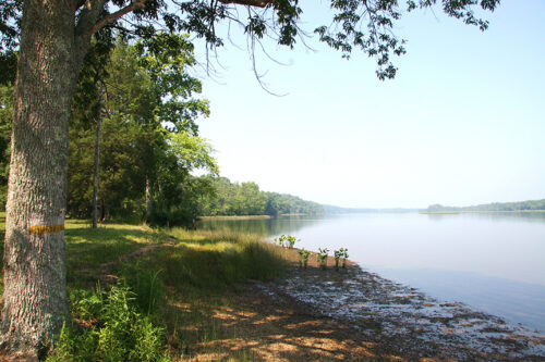
Most Virginia state forests are accessible to the public. Virginia’s state forests offer abundant passive recreational activities, such as hiking, biking, horseback riding, hunting, and fishing. Permissible uses vary among individual forests, so visit the web page for each state forest to find out what is allowed and available.
While you won’t find amenities like cabins, campgrounds, or even restrooms at most state forests, you will find unique opportunities to enjoy the outdoors and observe wildlife and forestry practices in action. A State Forest Use Permit is required for hunting, trapping, fishing, mountain biking, and horseback riding; other appropriate licenses may be additionally required for certain activities (i.e., hunting, trapping, fishing).
Visitors asked to adopt a “leave-no-trace” ethic when visiting the forest, as there are generally no restrooms or trash cans on the forests themselves.
Learn more about recreation and hunting on state forests.
Before You Visit
To ensure your safety and enjoyment, please read Before You Visit when planning your trip to a state forest.
Download or print the state forest map and directions for the forest you wish to visit – many state forests are remote with limited cell phone service. These maps will work with Avenza Maps™, a mobile map app that allows you to track your movements offline on your iOS and Android device without the need for cell service or internet connection. A free version of this app can be downloaded to your device through your app store.
State Forests Differ from State Parks and Other State Lands
Ever wonder just what the difference is between state forests, state parks, wildlife management areas, natural area preserves, national forests, and national parks? Learn just what the difference is.
Additional Resources
Additional Resources
| Image | Title | ID | Description | Date | Content Type | View | hf:tax:document-category | hf:tax:document-tags | hf:tax:Media |
|---|---|---|---|---|---|---|---|---|---|
 | Hunter Protocol for Lottery Hunts – Conway Robinson State Forest | Document provides protocol, requirements, and important dates for lottery permit hunting at Conway Robinson State Forest. | August 12, 2021 | Document | View | state-forests | conway-robinson-sf hunting state-forest-recreation | document | |
 | Charlotte State Forest – Hunting Map | Hunting map of Charlotte State Forest. Maps work with Avenza Maps app for offline tracking on mobile devices. Download or print before your visit. | March 28, 2022 | Map | View | state-forests | charlotte-sf hunting state-forest-recreation | map | |
 | Sandy Point State Forest – Hunting Map | Hunting map of Sandy Point State Forest. Maps work with Avenza Maps app for offline tracking on mobile devices. Download or print before your visit. | September 7, 2022 | Map | View | state-forests | hunting sandy-point-sf state-forest-recreation | map | |
 | Chesterfield State Forest – Hunting Map | Hunting map of Chesterfield State Forest. Maps work with Avenza Maps app for offline tracking on mobile devices. Download or print before your visit. | August 28, 2023 | Map | View | state-forests | chesterfield-sf hunting state-forest-recreation | map | |
 | Matthews State Forest – Hunting Map | Hunting map of Matthews State Forest. Maps work with Avenza Maps app for offline tracking on mobile devices. Download or print before your visit. | August 28, 2023 | Map | View | state-forests | hunting matthews-sf state-forest-recreation | map | |
 | Charlotte State Forest – General Map | General map of Charlotte State Forest. Maps work with Avenza Maps app for offline tracking on mobile devices. Download or print before your visit. | March 28, 2022 | Map | View | state-forests | charlotte-sf state-forest-recreation | map | |
| Sandy Point State Forest Hunting Season Brief | Information sheet summarizes hunting seasons, dates, and times for Sandy Point State Forest. | September 26, 2022 | Document | View | state-forests | hunting sandy-point-sf state-forest-recreation | document | ||
| Prince Edward-Gallion State Forest Hunting Season Brief | Information sheet summarizes hunting seasons, dates, and times for Prince Edward-Gallion State Forest. | August 30, 2023 | Document | View | state-forests | hunting prince-edward-gallion-sf state-forest-recreation | document | ||
| Moore’s Creek State Forest Hunting Season Brief | Information sheet summarizes hunting seasons, dates, and times for Moore’s Creek State Forest. | August 30, 2023 | Document | View | state-forests | hunting moores-creek-sf state-forest-recreation | document | ||
| Matthews State Forest Hunting Season Brief | Information sheet summarizes hunting seasons, dates, and times for Matthews State Forest. | August 30, 2023 | Document | View | state-forests | hunting matthews-sf state-forest-recreation | document | ||
| Lesesne State Forest Hunting Season Brief | Information sheet summarizes hunting seasons, dates, and times for Lesesne State Forest. | August 30, 2023 | Document | View | state-forests | hunting lesesne-sf state-forest-recreation | document | ||
| First Mountain State Forest Hunting Season Brief | Information sheet summarizes hunting seasons, dates, and times for First Mountain State Forest. | August 30, 2023 | Document | View | state-forests | first-mountain-sf hunting state-forest-recreation | document | ||
| Dragon Run State Forest Hunting Season Brief | Information sheet summarizes hunting seasons, dates, and times for Dragon Run State Forest. | August 30, 2023 | Document | View | state-forests | dragon-run-sf hunting state-forest-recreation | document | ||
| Devil’s Backbone State Forest Hunting Season Brief | Information sheet summarizes hunting seasons, dates, and times for Devil’s Backbone State Forest. | August 30, 2023 | Document | View | state-forests | devils-backbone-sf hunting state-forest-recreation | document | ||
| Cumberland State Forest Hunting Season Brief | Information sheet summarizes hunting seasons, dates, and times for Cumberland State Forest. | August 30, 2023 | Document | View | state-forests | cumberland-sf hunting state-forest-recreation | document | ||
 | Chesterfield State Forest Hunting Season Brief | Information sheet summarizes hunting seasons, dates, and times for Chesterfield State Forest. | August 30, 2023 | Document | View | state-forests | chesterfield-sf hunting state-forest-recreation | document | |
| Chilton Woods State Forest Hunting Season Brief | Information sheet summarizes hunting seasons, dates, and times for Chilton Woods State Forest. | August 30, 2023 | Document | View | state-forests | chilton-woods-sf hunting state-forest-recreation | document | ||
| Charlotte State Forest Hunting Season Brief | Information sheet summarizes hunting seasons, dates, and times for Charlotte State Forest. | August 30, 2023 | Document | View | state-forests | charlotte-sf hunting state-forest-recreation | document | ||
| Channels State Forest Hunting Season Brief | Information sheet summarizes hunting seasons, dates, and times for Channels State Forest. | August 30, 2023 | Document | View | state-forests | channels-sf hunting state-forest-recreation | document | ||
| Browne State Forest Hunting Season Brief | Information sheet summarizes hunting seasons, dates, and times for Browne State Forest. | August 30, 2023 | Document | View | state-forests | browne-sf hunting state-forest-recreation | document | ||
| Appomattox-Buckingham State Forest Hunting Season Brief | Information sheet summarizes hunting seasons, dates, and times for Appomattox-Buckingham State Forest. | August 30, 2023 | Document | View | state-forests | appomattox-buckingham-sf hunting state-forest-recreation | document | ||
| Big Woods State Forest Hunting Season Brief | Information sheet summarizes hunting seasons, dates, and times for Big Woods State Forest. | August 22, 2025 | Document | View | state-forests | big-woods-sf hunting state-forest-recreation | document | ||
 | Matthews State Forest Deer Hunting Workshop and Mentored Hunt 2025 | Flyer advertising the Matthews State Forest Hunting Workshop September 13, 2025, and Mentored Hunt September 27, 2025. | September 5, 2023 | Document | View | education state-forests public-information | hunting matthews-sf | document | |
 | Devil’s Backbone State Forest – General Map | General map of Devil’s Backbone State Forest. To ensure your safety and enjoyment, please read Before You Visit when planning your trip to a state forest. Download or print this state forest map – many state forests are remote with limited cell phone service. These maps will work with Avenza Maps™, a mobile map app that allows you to track your movements offline on your iOS and Android device without the need for cell service or internet connection. A free version of this app can be downloaded to your device through your app store. | December 16, 2021 | Map | View | state-forests | devils-backbone-sf state-forest-recreation | map | |
 | Devil’s Backbone State Forest – Hunting Map | Hunting map of Devil’s Backbone State Forest. To ensure your safety and enjoyment, please read Before You Visit when planning your trip to a state forest. Download or print this state forest map – many state forests are remote with limited cell phone service. These maps will work with Avenza Maps™, a mobile map app that allows you to track your movements offline on your iOS and Android device without the need for cell service or internet connection. A free version of this app can be downloaded to your device through your app store. | December 16, 2021 | Map | View | state-forests | devils-backbone-sf hunting state-forest-recreation | map | |
| Cumberland State Forest – Hunting Map | Hunting map of Cumberland State Forest. To ensure your safety and enjoyment, please read Before You Visit when planning your trip to a state forest. Download or print this state forest map – many state forests are remote with limited cell phone service. These maps will work with Avenza Maps™, a mobile map app that allows you to track your movements offline on your iOS and Android device without the need for cell service or internet connection. A free version of this app can be downloaded to your device through your app store. | August 28, 2023 | Map | View | state-forests | cumberland-sf hunting state-forest-recreation | map | ||
| Cumberland State Forest – General Map | General map of Cumberland State Forest. To ensure your safety and enjoyment, please read Before You Visit when planning your trip to a state forest. Download or print this state forest map – many state forests are remote with limited cell phone service. These maps will work with Avenza Maps™, a mobile map app that allows you to track your movements offline on your iOS and Android device without the need for cell service or internet connection. A free version of this app can be downloaded to your device through your app store. | August 28, 2023 | Map | View | state-forests | cumberland-sf state-forest-recreation | map | ||
 | Zoar State Forest – General Map | General map of Zoar State Forest. To ensure your safety and enjoyment, please read Before You Visit when planning your trip to a state forest. Download or print this state forest map – many state forests are remote with limited cell phone service. These maps will work with Avenza Maps™, a mobile map app that allows you to track your movements offline on your iOS and Android device without the need for cell service or internet connection. A free version of this app can be downloaded to your device through your app store. | August 12, 2021 | Map | View | state-forests | state-forest-recreation zoar-sf | map | |
 | Conway Robinson State Forest – General Map | General map of Conway Robinson State Forest. To ensure your safety and enjoyment, please read Before You Visit when planning your trip to a state forest. Download or print this state forest map – many state forests are remote with limited cell phone service. These maps will work with Avenza Maps™, a mobile map app that allows you to track your movements offline on your iOS and Android device without the need for cell service or internet connection. A free version of this app can be downloaded to your device through your app store. | March 10, 2022 | Map | View | state-forests | conway-robinson-sf state-forest-recreation | map | |
| Appomattox-Buckingham State Forest – Hunting Map | Hunting map of Appomattox-Buckingham State Forest. To ensure your safety and enjoyment, please read Before You Visit when planning your trip to a state forest. Download or print this state forest map – many state forests are remote with limited cell phone service. These maps will work with Avenza Maps™, a mobile map app that allows you to track your movements offline on your iOS and Android device without the need for cell service or internet connection. A free version of this app can be downloaded to your device through your app store. | August 28, 2023 | Map | View | state-forests | appomattox-buckingham-sf hunting state-forest-recreation | map | ||
 | Bourassa State Forest – General Map | General map of Bourassa State Forest. To ensure your safety and enjoyment, please read Before You Visit when planning your trip to a state forest. Download or print this state forest map – many state forests are remote with limited cell phone service. These maps will work with Avenza Maps™, a mobile map app that allows you to track your movements offline on your iOS and Android device without the need for cell service or internet connection. A free version of this app can be downloaded to your device through your app store. | August 28, 2023 | Map | View | state-forests | bourassa-sf | map | |
 | Big Woods State Forest – General Map | General map of Big Woods State Forest. To ensure your safety and enjoyment, please read Before You Visit when planning your trip to a state forest. Download or print this state forest map – many state forests are remote with limited cell phone service. These maps will work with Avenza Maps™, a mobile map app that allows you to track your movements offline on your iOS and Android device without the need for cell service or internet connection. A free version of this app can be downloaded to your device through your app store. | August 10, 2021 | Map | View | state-forests | big-woods-sf state-forest-recreation | map | |
 | Big Woods State Forest – Hunting Map | Hunting map of Big Woods State Forest. To ensure your safety and enjoyment, please read Before You Visit when planning your trip to a state forest. Download or print this state forest map – many state forests are remote with limited cell phone service. These maps will work with Avenza Maps™, a mobile map app that allows you to track your movements offline on your iOS and Android device without the need for cell service or internet connection. A free version of this app can be downloaded to your device through your app store. | August 10, 2021 | Map | View | state-forests | big-woods-sf hunting state-forest-recreation | map | |
 | Crawfords State Forest – General Map | General map of Crawfords State Forest. To ensure your safety and enjoyment, please read Before You Visit when planning your trip to a state forest. Download or print this state forest map – many state forests are remote with limited cell phone service. These maps will work with Avenza Maps™, a mobile map app that allows you to track your movements offline on your iOS and Android device without the need for cell service or internet connection. A free version of this app can be downloaded to your device through your app store. | August 10, 2021 | Map | View | state-forests | crawfords-sf state-forest-recreation | map | |
 | Sandy Point State Forest – General Map | General map of Sandy Point State Forest. To ensure your safety and enjoyment, please read Before You Visit when planning your trip to a state forest. Download or print this state forest map – many state forests are remote with limited cell phone service. These maps will work with Avenza Maps™, a mobile map app that allows you to track your movements offline on your iOS and Android device without the need for cell service or internet connection. A free version of this app can be downloaded to your device through your app store. | August 12, 2021 | Map | View | state-forests | sandy-point-sf state-forest-recreation | map | |
 | First Mountain State Forest – Hunting Map | Hunting map of First Mountain State Forest. To ensure your safety and enjoyment, please read Before You Visit when planning your trip to a state forest. Download or print this state forest map – many state forests are remote with limited cell phone service. These maps will work with Avenza Maps™, a mobile map app that allows you to track your movements offline on your iOS and Android device without the need for cell service or internet connection. A free version of this app can be downloaded to your device through your app store. | November 8, 2021 | Map | View | state-forests | first-mountain-sf hunting state-forest-recreation | map | |
 | First Mountain State Forest – General Map | General map of First Mountain State Forest. To ensure your safety and enjoyment, please read Before You Visit when planning your trip to a state forest. Download or print this state forest map – many state forests are remote with limited cell phone service. These maps will work with Avenza Maps™, a mobile map app that allows you to track your movements offline on your iOS and Android device without the need for cell service or internet connection. A free version of this app can be downloaded to your device through your app store. | November 18, 2021 | Map | View | state-forests | first-mountain-sf state-forest-recreation | map | |
 | Paul State Forest – General Map | General map of Paul State Forest. To ensure your safety and enjoyment, please read Before You Visit when planning your trip to a state forest. Download or print this state forest map – many state forests are remote with limited cell phone service. These maps will work with Avenza Maps™, a mobile map app that allows you to track your movements offline on your iOS and Android device without the need for cell service or internet connection. A free version of this app can be downloaded to your device through your app store. | January 24, 2022 | Map | View | state-forests | paul-sf state-forest-recreation | map | |
 | Moore’s Creek State Forest – General Map | General map of Moore’s Creek State Forest. To ensure your safety and enjoyment, please read Before You Visit when planning your trip to a state forest. Download or print this state forest map – many state forests are remote with limited cell phone service. These maps will work with Avenza Maps™, a mobile map app that allows you to track your movements offline on your iOS and Android device without the need for cell service or internet connection. A free version of this app can be downloaded to your device through your app store. | August 28, 2023 | Map | View | state-forests | moores-creek-sf state-forest-recreation | map | |
 | Old Flat State Forest – General Map | General map of Old Flat State Forest. To ensure your safety and enjoyment, please read Before You Visit when planning your trip to a state forest. Download or print this state forest map – many state forests are remote with limited cell phone service. These maps will work with Avenza Maps™, a mobile map app that allows you to track your movements offline on your iOS and Android device without the need for cell service or internet connection. A free version of this app can be downloaded to your device through your app store. | August 28, 2023 | Map | View | state-forests | old-flat-sf state-forest-recreation | map | |
 | Prince Edward-Gallion State Forest – General Map | General map of Prince Edward-Gallion State Forest. To ensure your safety and enjoyment, please read Before You Visit when planning your trip to a state forest. Download or print this state forest map – many state forests are remote with limited cell phone service. These maps will work with Avenza Maps™, a mobile map app that allows you to track your movements offline on your iOS and Android device without the need for cell service or internet connection. A free version of this app can be downloaded to your device through your app store. | August 28, 2023 | Map | View | state-forests | prince-edward-gallion-sf state-forest-recreation | map | |
 | Moore’s Creek State Forest – Hunting Map | Hunting map of Moore’s Creek State Forest. To ensure your safety and enjoyment, please read Before You Visit when planning your trip to a state forest. Download or print this state forest map – many state forests are remote with limited cell phone service. These maps will work with Avenza Maps™, a mobile map app that allows you to track your movements offline on your iOS and Android device without the need for cell service or internet connection. A free version of this app can be downloaded to your device through your app store. | August 28, 2023 | Map | View | state-forests | hunting moores-creek-sf state-forest-recreation | map | |
 | Prince Edward-Gallion State Forest – Hunting Map | Hunting map of Prince Edward-Gallion State Forest. To ensure your safety and enjoyment, please read Before You Visit when planning your trip to a state forest. Download or print this state forest map – many state forests are remote with limited cell phone service. These maps will work with Avenza Maps™, a mobile map app that allows you to track your movements offline on your iOS and Android device without the need for cell service or internet connection. A free version of this app can be downloaded to your device through your app store. | August 28, 2023 | Map | View | state-forests | hunting prince-edward-gallion-sf state-forest-recreation | map | |
| Appomattox-Buckingham State Forest – General Map | General map of Appomattox-Buckingham State Forest. To ensure your safety and enjoyment, please read Before You Visit when planning your trip to a state forest. Download or print this state forest map – many state forests are remote with limited cell phone service. These maps will work with Avenza Maps™, a mobile map app that allows you to track your movements offline on your iOS and Android device without the need for cell service or internet connection. A free version of this app can be downloaded to your device through your app store. | August 28, 2023 | Map | View | state-forests | appomattox-buckingham-sf state-forest-recreation | map | ||
 | Dragon Run State Forest – General Map | General map of Dragon Run State Forest. To ensure your safety and enjoyment, please read Before You Visit when planning your trip to a state forest. Download or print this state forest map – many state forests are remote with limited cell phone service. These maps will work with Avenza Maps™, a mobile map app that allows you to track your movements offline on your iOS and Android device without the need for cell service or internet connection. A free version of this app can be downloaded to your device through your app store. | August 12, 2021 | Map | View | state-forests | dragon-run-sf state-forest-recreation | map | |
 | Dragon Run State Forest – Hunting Map | Hunting map of Dragon Run State Forest. To ensure your safety and enjoyment, please read Before You Visit when planning your trip to a state forest. Download or print this state forest map – many state forests are remote with limited cell phone service. These maps will work with Avenza Maps™, a mobile map app that allows you to track your movements offline on your iOS and Android device without the need for cell service or internet connection. A free version of this app can be downloaded to your device through your app store. | August 12, 2021 | Map | View | state-forests | dragon-run-sf hunting state-forest-recreation | map | |
 | Matthews State Forest – General Map | General map of Matthews State Forest. To ensure your safety and enjoyment, please read Before You Visit when planning your trip to a state forest. Download or print this state forest map – many state forests are remote with limited cell phone service. These maps will work with Avenza Maps™, a mobile map app that allows you to track your movements offline on your iOS and Android device without the need for cell service or internet connection. A free version of this app can be downloaded to your device through your app store. | August 28, 2023 | Map | View | state-forests | matthews-sf state-forest-recreation | map | |
 | Hawks State Forest – General Map | General map of Hawks State Forest. To ensure your safety and enjoyment, please read Before You Visit when planning your trip to a state forest. Download or print this state forest map – many state forests are remote with limited cell phone service. These maps will work with Avenza Maps™, a mobile map app that allows you to track your movements offline on your iOS and Android device without the need for cell service or internet connection. A free version of this app can be downloaded to your device through your app store. | August 28, 2023 | Map | View | state-forests | hawks-sf state-forest-recreation | map | |
 | Lesesne State Forest – Hunting Map | Hunting map of Lesesne State Forest. To ensure your safety and enjoyment, please read Before You Visit when planning your trip to a state forest. Download or print this state forest map – many state forests are remote with limited cell phone service. These maps will work with Avenza Maps™, a mobile map app that allows you to track your movements offline on your iOS and Android device without the need for cell service or internet connection. A free version of this app can be downloaded to your device through your app store. | January 11, 2022 | Map | View | state-forests | hunting lesesne-sf state-forest-recreation | map | |
 | Lesesne State Forest – General Map | General map of Lesesne State Forest. To ensure your safety and enjoyment, please read Before You Visit when planning your trip to a state forest. Download or print this state forest map – many state forests are remote with limited cell phone service. These maps will work with Avenza Maps™, a mobile map app that allows you to track your movements offline on your iOS and Android device without the need for cell service or internet connection. A free version of this app can be downloaded to your device through your app store. | January 13, 2022 | Map | View | state-forests | lesesne-sf state-forest-recreation | map | |
 | Whitney State Forest – General Map | General map of Whitney State Forest. To ensure your safety and enjoyment, please read Before You Visit when planning your trip to a state forest. Download or print this state forest map – many state forests are remote with limited cell phone service. These maps will work with Avenza Maps™, a mobile map app that allows you to track your movements offline on your iOS and Android device without the need for cell service or internet connection. A free version of this app can be downloaded to your device through your app store. | February 7, 2022 | Map | View | state-forests | state-forest-recreation whitney-sf | map | |
 | Niday Place State Forest – General Map | General map of Niday Place State Forest. To ensure your safety and enjoyment, please read Before You Visit when planning your trip to a state forest. Download or print this state forest map – many state forests are remote with limited cell phone service. These maps will work with Avenza Maps™, a mobile map app that allows you to track your movements offline on your iOS and Android device without the need for cell service or internet connection. A free version of this app can be downloaded to your device through your app store. | August 28, 2023 | Map | View | state-forests | niday-place-sf state-forest-recreation | map | |
 | Chilton Woods State Forest – General Map | General map of Chilton Woods State Forest. To ensure your safety and enjoyment, please read Before You Visit when planning your trip to a state forest. Download or print this state forest map – many state forests are remote with limited cell phone service. These maps will work with Avenza Maps™, a mobile map app that allows you to track your movements offline on your iOS and Android device without the need for cell service or internet connection. A free version of this app can be downloaded to your device through your app store. | August 10, 2021 | Map | View | state-forests | chilton-woods-sf state-forest-recreation | map | |
 | Chilton Woods State Forest – Hunting Map | Hunting map of Chilton Woods State Forest. To ensure your safety and enjoyment, please read Before You Visit when planning your trip to a state forest. Download or print this state forest map – many state forests are remote with limited cell phone service. These maps will work with Avenza Maps™, a mobile map app that allows you to track your movements offline on your iOS and Android device without the need for cell service or internet connection. A free version of this app can be downloaded to your device through your app store. | August 10, 2021 | Map | View | state-forests | chilton-woods-sf hunting state-forest-recreation | map | |
 | Browne State Forest – General Map | General map of Browne State Forest. To ensure your safety and enjoyment, please read Before You Visit when planning your trip to a state forest. Download or print this state forest map – many state forests are remote with limited cell phone service. These maps will work with Avenza Maps™, a mobile map app that allows you to track your movements offline on your iOS and Android device without the need for cell service or internet connection. A free version of this app can be downloaded to your device through your app store. | August 10, 2021 | Map | View | state-forests | browne-sf state-forest-recreation | map | |
 | Browne State Forest – Hunting Map | Hunting map of Browne State Forest. To ensure your safety and enjoyment, please read Before You Visit when planning your trip to a state forest. Download or print this state forest map – many state forests are remote with limited cell phone service. These maps will work with Avenza Maps™, a mobile map app that allows you to track your movements offline on your iOS and Android device without the need for cell service or internet connection. A free version of this app can be downloaded to your device through your app store. | August 10, 2021 | Map | View | state-forests | browne-sf hunting state-forest-recreation | map | |
 | Chesterfield State Forest – General Map | General map of Chesterfield State Forest. To ensure your safety and enjoyment, please read Before You Visit when planning your trip to a state forest. Download or print this state forest map – many state forests are remote with limited cell phone service. These maps will work with Avenza Maps™, a mobile map app that allows you to track your movements offline on your iOS and Android device without the need for cell service or internet connection. A free version of this app can be downloaded to your device through your app store. | August 12, 2021 | Map | View | state-forests | chesterfield-sf state-forest-recreation | map | |
 | Channels State Forest – Hunting Map | Hunting map of Channels State Forest. To ensure your safety and enjoyment, please read Before You Visit when planning your trip to a state forest. Download or print this state forest map – many state forests are remote with limited cell phone service. These maps will work with Avenza Maps™, a mobile map app that allows you to track your movements offline on your iOS and Android device without the need for cell service or internet connection. A free version of this app can be downloaded to your device through your app store. | August 28, 2023 | Map | View | state-forests | channels-sf hunting state-forest-recreation | map | |
 | Channels State Forest – General Map | General map of Channels State Forest. To ensure your safety and enjoyment, please read Before You Visit when planning your trip to a state forest. Download or print this state forest map – many state forests are remote with limited cell phone service. These maps will work with Avenza Maps™, a mobile map app that allows you to track your movements offline on your iOS and Android device without the need for cell service or internet connection. A free version of this app can be downloaded to your device through your app store. | August 28, 2023 | Map | View | state-forests | channels-sf state-forest-recreation | map | |
 | South Quay State Forest – General Map | General map of South Quay State Forest. To ensure your safety and enjoyment, please read Before You Visit when planning your trip to a state forest. Download or print this state forest map – many state forests are remote with limited cell phone service. These maps will work with Avenza Maps™, a mobile map app that allows you to track your movements offline on your iOS and Android device without the need for cell service or internet connection. A free version of this app can be downloaded to your device through your app store. | August 12, 2021 | Map | View | state-forests | south-quay-sf | map | |
| Tree Seedling and Understory Plant Presence in Deer Exclosures on the Matthews State Forest | CNRE-138NP | The purpose of this case study was to determine the impact of deer on the composition of the herbaceous and regeneration layer in two stands in the Matthews State Forest. This report summarizes the findings of this case study. | February 10, 2022 | Publication | View | forest-management nurseries research-resource-information state-forests resource-information | 2 wildlife | publication | |
| Impact of Planting Treatments on Eastern White Pine Seedling Survival and Growth at the Matthews State Forest in Grayson County, Virginia | CNRE-137NP | As part of an undergraduate research project, two Virginia Tech students collected data in a white pine seedling survival study to determine which planting treatments had the best survival and growth rates. The test plot was located on the Matthews State Forest in Grayson County, Virginia. This report summarizes the findings of this case study. | February 10, 2022 | Publication | View | forest-management research-resource-information state-forests resource-information | matthews-sf white-pine | publication | |
| Appomattox-Buckingham State Forest Recreation and Trails Map | P00171 | Map introduces recreation and trails, including trail segments, descriptions and distances, located on the Appomattox-Buckingham State Forest in Appomattox and Buckingham counties. | November 3, 2020 | Publication | View | state-forests | appomattox-buckingham-sf recreation state-forest-recreation | publication | |
| Cumberland State Forest Recreation and Trails Map | P00170 | Map introduces recreation and trails, including trail segments, descriptions and distances, located on the Cumberland State Forest in Cumberland County. | November 3, 2020 | Publication | View | state-forests | cumberland-sf recreation state-forest-recreation | publication |
Contact Us
Contact Us
For more information or questions, e-mail us with “state forest name” in the subject line for specific state forest inquiries.
1 SFI marks are registered marks owned by the Sustainable Forestry Initiative Inc.